|
|
|
Literature SurveyIn this chapter, the literature surveys introduce “Virtual Heritage” and “Heritage Documentation and Presentation” projects attempted around the world and discuss the advantages and disadvantages of the techniques and concepts used in them. The data collected through this survey will then be used to identify and justify the main elements, requirements and objectives of the proposed project. The literature survey is arranged in a manner that sequentially portrays the birth and development of the “Virtual Heritage” concept. Terminology needed to understand the various concepts in a Virtual Heritage project are discussed in the first part (2.1). The second part (2.2) describes various methods, traditional and modern, presently used to capture the data, as these methods are the primary basis of preserving the built heritage through documentation. Once the data has been captured, it needs to be presented and made accessible in various forms depending on the target audience. Target audience could be specialists like architects, heritage conservationists, historians and students or even the general population. This is discussed by using an example in the third part (2.3). The fourth (2.4) and fifth (2.5) part introduces and describes in detail two new media techniques, these being pseudo-3D-immersive environment using panoramic views and “Virtual Reality” using 3D-models. Finally, the last part (2.6) describes some other issues involved in using the techniques presented in this survey and the proposed project. 2.1 TerminologyThe proposed project can be broadly categorized into two parts, first is Architecture and second, Virtual Reality. Under Architecture, terms like “Measured drawings”, “Photography”, and “Written Histories” are explained, while under “Virtual Reality”, terms like “Real-time rendering”, “Polygon count”, “Level of Detail models”, “Culling Techniques” and finally “Textures, Lights and Cameras” are explained. 2.1.1 Measured Drawings: These are orthographic projections or in simple terms, 2 dimensional line drawings showing the plans at various floor levels (horizontal sections), elevations or facades from all sides, sections at critical positions (to a manageable scale and referenced in the plan and or elevations) and blown up details (to larger scale), again in the above three forms. Sometimes isometric drawings are provided for clarity of a three dimensional structure. Isometric drawings are a form of perspective drawings but are drawn to true dimensions. The drawings contain all possible dimensions and details adequate to reconstruct the whole structure. These drawings are derived from the surveyed data and hence made after the structure has already been built as opposed to working drawings, which look similar and have the same details. Working drawings are drawings given to a contractor for building a proposed structure. 2.1.2 Photography: Large format perspective correction cameras are used to photo-document any structure. Photographs show the exact context and placement of the structure to its physical surroundings and the exact physical condition during the period in which the surveying was conducted. Photo-documentation is important as they describe many things like textures, spatial relations etc. (WWW1) that would be difficult to portray in terms of drawings or natural language. 2.1.3 Written Histories: These are textual descriptions researched and composed by historians. These discuss the historical context of the structure under consideration. Other textual information may also include the building materials used for the structure, the age of the building, any reconstruction, alterations, additions or restoration histories etc. 2.1.4 Real-time rendering: The human eye perceives motion when images with miniscule changes are continuously shown at the minimum rate of 10 images per second. Normally for a very smooth motion, 24 images per second are required. Commercial animation films, whether computer generated or traditionally made, make use of these frame rates for achieving motion. For a computer to render (create) one image, it may take anywhere between a few seconds to a few hours, depending upon the scene complexity and the computing power. When these frames are played back at the prescribed frame rate, we perceive animation. These are termed as “pre-rendered” animations. Here, the animator fixes the path of the viewer. The viewer cannot choose where he wants to go next as the path is already fixed. There is complete lack of interaction. Virtual reality comes into picture when the viewer wants to dictate his own path or interact with the objects in the animation. This situation requires the computer to render any scene on the fly optimally at 24 frames per second, in order to get a smooth walk through. This concept is called real-time rendering. Few years back, this concept was limited only to research institutes and big commercial institutes capable of investing huge amounts of money for research and advertisement respectively. This was primarily because of heavy computing power required to render images at 24 frames per second as opposed to one frame per few minutes for pre rendered animations. Yet, the scene complexity had to be kept to a standard minimum, as even the mightiest of the computers could not render images at the required rate. This affects the reality and accuracy of the scene. Today we see the desktop computer crossing the 1Ghz mark along with major improvements in hardware supporting graphics. This has brought the virtual-reality to our desktop although on a lower scale. Early animations were rendered in 2 dimensions. Today we have three-dimensional animations, which make use of 3d models and virtual camera’s to render a 3d animation. The same 3d model can be used to achieve virtual reality, although it requires scaling down the complexity and accuracy of the model, in order to make the model fit for the available processing power to render in real time. 2.1.5 Polygon count - The number of triangular faces (polygons obtained by joining three vertices) required for making a 3d model for real time rendering. 2.1.6 Level of detail models - The accuracy of a model depends on the number of polygons used to make that model. More the number of polygons, greater is the level of accuracy. But this also has a repercussion on the render time. Hence, various models with varying number of polygons of the same model are made. When that particular model is at a large distance from the viewer, lower number of polygons is used. 2.1.7 Culling, Laurila(1999) & Moller et al (1999): Many culling methods are used to make a smooth walk through the virtual environment (i.e. to get a frame rate between 15 to 24 frames per second). As mentioned earlier, the number of polygons directly affects the frame rate of the real time render. Hence, for a huge scene, the model can be broken down into small blocks of objects containing those many numbers of polygons such that the computer can render them easily in realtime. The objects in the environment can be broken down depending upon the type of textures used in the scene (see “Textures” later). The most commonly used culling methods are a) view frustum culling method where, only those objects that are seen in the view are rendered, rest are ignored. b) occlusion culling method where, polygons are not rendered if they are not seen in the view due to obstruction of another polygon or object. c) back face culling method where, if the polygons don’t face the viewer, then they are not rendered. 2.1.8 Textures, Lights and
Cameras: Textures are mapped onto polygons of the model. These textures are
basically digital images, which represent the real world material of the
model. Textures, along with proper lighting conditions, enhance the reality
of a virtual scene, but usage of many textures and lights can also place a
very high overhead for computing. Hence these have to be used very judiciously,
without affecting the reality of the scene. Normally, only one camera
position is sufficient, and this represents the users point of view. The
scene is rendered as seen from this camera. 2.2 Built
Heritage Data Capture (Top)
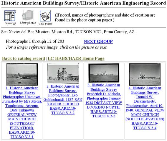
Three main steps are involved in accurate and complete documentation of a built heritage, these being “Surveying of Built Heritage”, “Photo-Documentation”, and “Written Histories and other documentation”. 2.2.1 Surveying of Built Heritage Surveying is basically capturing of dimensions of the built heritage under consideration, through surveying techniques, photogrammetry and 3D laser scanners and converting them into manually drafted or computer aided drafted drawings. Manual surveying involves measuring dimensions of the structure under consideration. Before the start of the survey process, sketch drawings like plan (horizontal section), elevation (façade) and section (vertical section) that are to be measured, are drawn. A grid layout is formed around the structure to locate reference points. These points are used to measure the distances. As the distances are measured, they are filled in the sketched drawings. The grid is marked on the ground with string or chalk using theodolites and tape measure. This is called the Grid system, and is best used for surveying irregular structures and ruins. After all dimensions have been taken, the plan, elevation and section are drafted to produce measured drawings. These methods are time consuming, as they require a lot of prior onsite work and then conversion to drafted drawings, Patterson (1982). A photograph is a two dimensional representation of a three dimensional environment. During this conversion, some data is lost e.g. the depth. Photogrammetry can then be simply defined as conversion of this two dimensional representation of an environment, to a three dimensional representation (WWW10). As one dimension is not represented in an image, this process cannot be applied using a single photograph. To extract any legible data, atleast two photographs taken from different angles having common edges or points, are required. More photographs from different angles can lead to greater accuracy level of the extracted data. For any particular environment, one reference dimension should be known. This dimension is used as a scale for all the extracted data. Specialized cameras called metric cameras are used to take photographs of environment under consideration. The most important advantage of photogrammetry is that any structure can be measured without physically touching the structure. This method requires very short time for onsite work and is as accurate as manual surveys. Recent development in surveying techniques has lead to usage of 3D laser scanners, which captures the finest details of a structure under consideration. This method is the most accurate but requires huge monetary investment for the scanner itself and large computing power to process the captured data. Hence this method is not yet completely feasible. 2.2.2 Photo-documentation Photographs, black and white or coloured, capture the physical conditions and the exact texture of the materials used. Measured drawings are two dimensional in nature and provide enough dimensional details to completely reconstruct the structure. Yet these do not provide any visual context. Hence, Photo-documentation plays an important role in providing a visual feel for the structure. Photographs describe important aspects like the structure’s physical states, the state of the materials used for the structure, textures, patterns, the structure’s environment, furniture, the interiors etc. “The purpose of photographic documentation of historic structures is to preserve as much visual information about a structure in as few photographs as possible.” – David (year unknown). According to David Ames, the following six photographs are essential to successfully document a structure:
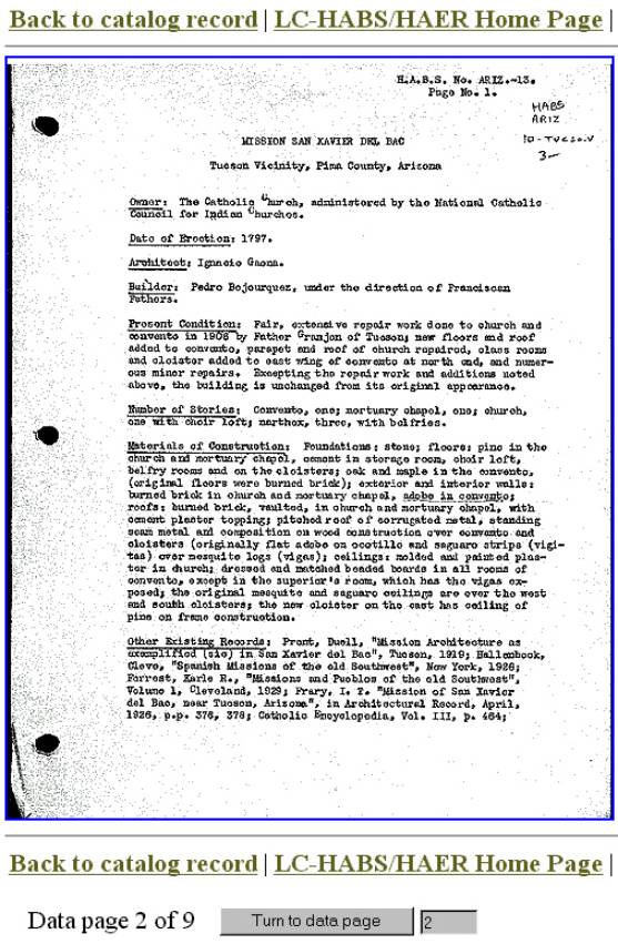
More photographs may be required depending upon the complexity of the structure. Photographs may be black and white or coloured and may be perspective corrected. 2.2.3 Written Histories and other documentation Documenting the history about a structure under consideration is as important as the measured drawings and photographs. Historians place the structure within an appropriate context, giving the historical and architectural importance, the origins, association with the communities, local, national or international connections etc. These histories provide a background on why the structure was built in that particular fashion. This may provide any missing information for reconstructing missing or dilapidated portions of a structure. Other documentation may involve recording the details about surveying histories, reconstruction or restoration histories, names of people involved in documenting the structure etc. After a colloquy by the European Council in October 1992, an international standard for documenting the textual information of a heritage structure was approved by 150 participants from 26 countries following a survey throughout the world’s heritage documenting institutes, Thornes et al (1998). 2.3 Categories of Virtual Heritage Systems (Top)Three types of virtual heritage systems have been identified from the existing or ongoing projects around the world. Firstly we have a “Non-interactive Internet based picture book system”. These systems are basically conversion of existing documents (measured drawings, photographs and data pages) in an electronic form (images of gif, jpeg or tiff format in various resolutions) and making them available on the Internet in a categorized form (categorization through structures, type of data, etc.) for easy access. As examples, we have
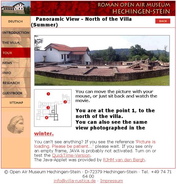
Secondly, we have “Pseudo-3D-immersive environments”. These environments are created from photographs taken from a fixed point, in all possible directions (mostly 6 – top, bottom, front, back, right and left) and seamlessly mapped on a cube or a sphere. The viewpoint is then defaulted to the fixed point from where the user can then view the stitched photographs in all possible directions, giving the user a feeling of virtually being at the site. Although it gives a feeling of the third dimension, the complete image is still a two dimensional distortion. Hence, we call this technology, pseudo 3D-immersive environment. This technology is popularized by Apple’s Quick-time VR. Hotspots can be created in these spheres, which create a link to other spheres, thus giving a feeling of user’s viewpoint being changed. These environments can be viewed with a standalone application or can be made accessible through the Internet by embedding the environment in an HTML file. “…QuickTime VR moves the photographic image from the flat, 2D world into a more immersive experience, complete with 3D imagery and interactive components” (WWW5). As examples, we have
And thirdly, we have “Virtual Reality or Immersive Environments”. The 3D environment is projected as the new revolution in terms of human computer interaction. For any user, a 3 dimensional environment is easy to perceive. Hence we see most of the 2D games being converted into 3D games besides many new games being made using 3D technologies. 3D technologies are not only used in the gaming industry, but also for research, development and testing many projects. Many critical decisions can be made prior to execution of any project, thus saving disastrous financial losses and even deaths. Today we see a lot of development and application of 3D technologies in the field of archaeology and architectural conservation. The most popular 3D technologies involve use of VRML technology (developed by Silicon Graphics and Template Graphics Software), 3D Gaming engines for real-time rendering (e.g. the Unreal game engine which is commercially available for development), and some indigenous rendering engines geared to render complex geometry. The advantage of using VRML is easy access to the virtual environment through the Internet. As examples, we have
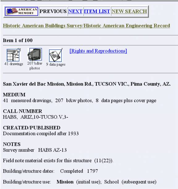
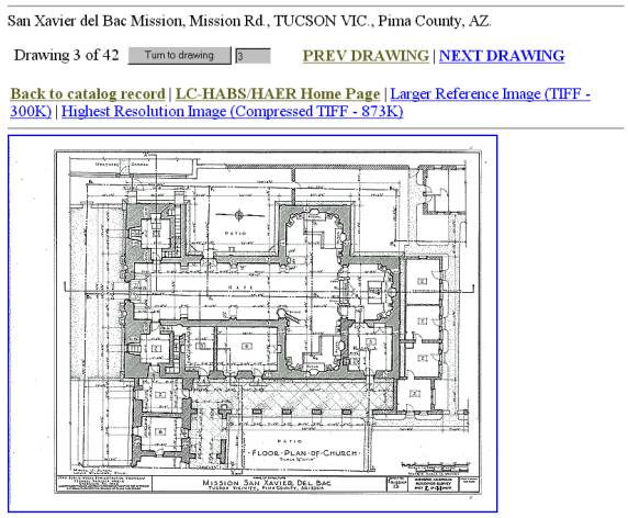
The first example from each type of system is taken up for a detailed discussion in sections 2.4, 2.5 and 2.6 2.4 Non-interactive Internet based picture book system (Top)The Historic American Buildings Survey/Historic American Engineering Record (HABS/HAER) is a program initiated by US Government to document important architectural, engineering and industrial sites throughout the United States and its territories. The original hard copies of the documentation are archived at the Library of Congress, which makes it available to the public. In 1933 the National Park Service, Department of the Interior established this program following a proposal by Charles E. Peterson, a Park Service landscape architect, in order to provide relief to jobless architects, draftsmen and photographers during and after the great depression (WWW1). For every monument existing in the USA and designated as heritage, this recent project is an attempt to preserve all available documentation by converting them in an electronic format and make it easily accessible world wide through the use of Internet. More recent documentation processes use CAD and other advanced techniques like photogrammetry etc. But the main emphasis is on digitizing existing documents. These electronic formats are made available in the public domain on the Internet in an organized and categorized fashion. These give a complete insight into the documenting and archiving process taken up by the US Government, besides providing an excellent easy resource for research work. 2.4.1 Organization The project website provides good search facilities for searching details of any available heritage structure by “keyword”, subject wise (normally name of heritage structure) lexicographical arrangement, and geographical location wise (location of heritage structure) lexicographical arrangement.
2.4.2. Categorization of details per structure For every heritage structure the following details are provided in image form on the website:
For all the digitized images, the corresponding “Originals” are catalogued and archived at the Library of Congress and the materials used for archiving are expected to last for 500 years. 2.4.3 Advantages and disadvantages
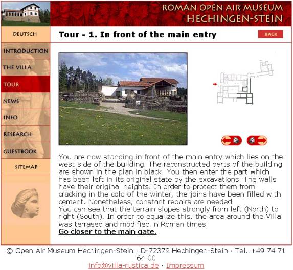
2.5 Pseudo-3D-immersive environments (Top)The Roman Open air museum at Hechingen-Stein (WWW4), Germany, has used the Internet technologies to effectively advertise and promote its existence through the use of Quick Time Virtual Reality and JAVA technologies. This website gives an excellent insight into what could be expected when a tourist makes an actual visit to this archaeological site and museum in southwestern Germany.
The main objective of this website is to give the visitors “close to real life” experience of this archaeological site and museum from the comfort of their home through the use of Internet. This website first gives an introduction to the Roman history related to this archaeological site along with suitable photographs. Further web pages lead into textual description of the excavation history, reconstruction and restoration history with appropriate orthographic projections and photographs, and the attractions available at the site (e.g. the Museum and snack bar). Finally, the website leads into two types of online tours:
This system describes the exact existing condition of the heritage site with the use of photographs, can be created quickly, gives a good reference between the plan view (orthographic projection), the textual description and the panoramic view and is very easy for layman to navigate with reference to top view. Hence, this system stands very advantageous for advertising and tourism purposes. But, it cannot be used to acquire accurate measurements from the environment hence not useful for experts and specialists, no reconstructions are possible, user interaction is limited only to navigation, and the user is restricted to the predefined viewpoints. 2.6 Virtual Reality and Immersive Environments (Top)The Glasgow Directory, Ennis et al (2000), uses VRML technology to create an information directory of all the important landmarks in Glasgow, which can be accessed easily through the Internet. The Directory uses a 3D model representing 25 sq.km of the city with topography, as a basis of navigation and reference to all the textual information. The 3D model consists of basic models of the buildings. The models are not textured have intermediate level of detail. The information is divided into various categories as follows:
All the information is referenced in the 3D model and can be referred from either the 3D model or by searching the textual information. The user interface is divided into five parts:
In this type of system, the reference material is available through out the world as it uses Internet technologies. Every landmark is appropriately referred to and from the 3D model, and the location plan uses an excellent method of showing the users current location with reference to the complete area under consideration. Hence this system is very useful in terms of cross-referencing related data. But, first time users have to rely on a lot of “Help” description to familiarize themselves with the site as there is too much information (with many options) presented in a single view. As the model does not show many details on the buildings, it is difficult for the user to associate a particular building with the referred photograph. Although Internet access speeds are increasing, majority of the people have access to narrow bandwidths. This presents a problem for download time of the 3d models. 2.7 Comparison of Virtual Heritage Systems (Top)The table below gives a comparative analysis between the three different types of Virtual Heritage systems and also the features that can are possible in the proposed system.
As we can see from the comparison table, the virtual reality system provides us a lot of functionality for various types of users through a user interface, which can be designed to vary from beginner level to expert level. The proposed system is based on extracting the advantages of the existing systems. 2.8 Other Issues (Top)Most international archaeological and heritage institutions do not consider making this type of data publicly available. This may be to avoid illegal usage either for illegal activities like planning of terrorist activities, storing of illegal substances in unmanned structures and other extreme activities. This data may also be used for many other legal purposes without acquiring the appropriate copyrights from the appropriate owner. But considering the HABS/HAER collections being easily available in the public domain on the Internet, the views of many archaeological and heritage institutions may start changing. The same issue is true for the proposed project. Hence, legal and security issues need to be addressed carefully. If the proposed project is implemented on a large scale, this can give rise to new kind of job opportunities for people who have skills in both fields – architecture and computing, and also for graphics programmers, architectural 3D modelers and texture artists. There will be no reduction in job prospects for existing professionals in the field of architectural conservation (surveyors, drafters, photographers) since the basis of the proposed method will always be orthographic projections. Despite many advances in the field of computer science, VR Technology is still in its infancy, if compared to achieving the “Complete Immersive Feeling”. This is only due to the hardware and software limitations. VR depends on creation of models. Greater the amount of details, higher is the feeling of reality; bigger is the overhead for computing. In view of many archaeologists and conservationists, current VR technology is still not adequate to suit accurate representation of a complex heritage structure. But looking at the advancement in technology, this mentality of the specialists is expected to change. A controversial and highly debatable thought is to consider the accuracy and feasibility of currently employed methods as discussed in 2.2 above. |
||||||||||||||||||||||||||||||||||||||||||||||||||||||||||||||||||||||||||||||||||||||||||||